comScore pixel
заснеженный горнолыжный курорт
Катание в France

Состояние снега в Notre Dame de Bellecombe

45.68° N 6.44° E

Прогноз погоды для Notre Dame de Bellecombe 1611 m высоте

Следующий снегопад в Notre Dame de Bellecombe:
1.2 cm в Сб 24
выпущен:
7 pm 23 Oct 2026 (местное время)
Прогноз снега обновлен в:
 ч  мин

Отчет о снеге в Notre Dame de Bellecombe:

Состояние снега в Notre Dame de Bellecombe: из 85 Открыто подъемников. Our model predicted that 4cm (1.6 inches) of snow fell over 6 hours between Friday 23 of October at 2PM and Friday 23 of October at 8PM CEST at the mid mountain level. Compacted depth will be less.


Количество свежевыпавшего снега:

Долговременная история снегопадов
4 cm
Fri 23 Oct
Источник:Report Origin

Последний существенный снегопад:

Ankle
7 cm
Fri 15 May (PM)
Источник:Report Origin

Глубина снега в Notre Dame de Bellecombe:

Снежный покров наверху:Snow RadarСообщите нам
Снежный покров внизу:

Условия в курорте Notre Dame de Bellecombe:

Наш отчет о снеге в Notre Dame de Bellecombe содержит ежедневные обновления состояния снега, глубины снежного покрова, условий на трассах и вне трасс, а также число работающих подъемнков. Последний отчет из Notre Dame de Bellecombe, показанный ниже, был обновлен 23 Oct 2026. Снежные отчеты предоставляются регулярно в течение горнолыжного сезона нашей сетью партнеров и менеджеров из курортов, а также Skiresort Service International GmbH. В дополнение к последнему отчету об условиях на склоне, мы показываем веб-камеры (включая 4-недельный архив изображений), текущие наблюдения с близлежащих метеостанций и исторические данные о климате в Notre Dame de Bellecombe.

Последний снегопад:

7 cm
May 14
6 cm
May 15
1.0 cm
May 16
4 cm
Oct 21

Отчет из курорта:

Условия на трассах:
Сообщите нам
Условия вне трасс:
Следующий снегопад:
6 cm Sat 24 Oct (AM)
Следующий существенный снегопад:
6 cm Sat 24 Oct (AM)
Открыто подъемников:
Спуски к курорту:

Состояние снега в Notre Dame de Bellecombe

  • 0
    Дней с ясной погодой при свежем снеге/пухе
  • 1
    Дней с пухом или свежим снегом
  • 1
    Дней с ясной погодой

Наблюдения около Notre Dame de Bellecombe:

  • 50 km расст. from Notre Dame de Bellecombe

    12 hour ранее
    weather station observation

    Light rain reported from Jarrier at 1330 metres elevation 5 kms NE of La Toussuire (Les Sybelles) but it is forecast cold enough for snow at the ski area from La Toussuire (Les Sybelles)

  • 35 km расст. from Notre Dame de Bellecombe

    13 hour ранее
    weather station observation

    Light rain reported from Haute-Savoie Mont Blanc Airport/Aéroport Annecy/Meythet at 711 metres elevation only 3 kms WNW of Annecy-LeSemnoz but it is forecast cold enough for snow at higher elevations in the ski area from Annecy-LeSemnoz

  • 35 km расст. from Notre Dame de Bellecombe

    15 hour ранее
    weather station observation

    Moderate rain reported from Haute-Savoie Mont Blanc Airport/Aéroport Annecy/Meythet at 711 metres elevation only 3 kms WNW of Annecy-LeSemnoz but it is forecast cold enough for snow at the ski area from Annecy-LeSemnoz

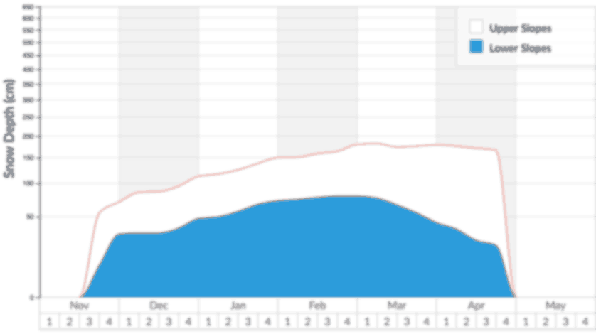
Глубина снега в Notre Dame de Bellecombe:

Зарегистрированная глубина снега в верхней и нижней части склона в Notre Dame de Bellecombe 2026. Долгосрочное среднее значение для верхней части склона также показано для сравнения

Отчеты о снеге из курортов около Notre Dame de Bellecombe

Найдите лучшие условия для горных лыж и сноуборда около Notre Dame de Bellecombe, используя нашу страницу поиска снега.

Курорт
Выпущено: 3 дней назад 10 km  расстояние
Выпущено: вчера 12 km  расстояние
Выпущено: вчера 14 km  расстояние
Вебкамера
Arêches-Beaufort ВебкамераНет камерыLes Saisies ВебкамераНет камерыНет камеры
Глубины снега
Верх склона
Низ склона
0 cm
0 cm
Верх склона
Низ склона
—
—
Верх склона
Низ склона
—
—
Верх склона
Низ склона
—
—
Верх склона
Низ склона
—
—
Состояние трасс
Последний снегопад
Количество:
Дата:
 3.0 cm
3 дней назад
Количество:
Дата:
 3.0 cm
3 дней назад
Количество:
Дата:
 4 cm
3 дней назад
Количество:
Дата:
 3.0 cm
3 дней назад
Количество:
Дата:
 4 cm
3 дней назад
Следующие 9 дней
0-3
3-6
6-9
6.0 cm
0.0 cm
0.0 cm
0-3
3-6
6-9
2.0 cm
0.0 cm
0.0 cm
0-3
3-6
6-9
7.0 cm
0.0 cm
0.0 cm
0-3
3-6
6-9
2.0 cm
0.0 cm
0.0 cm
0-3
3-6
6-9
7.0 cm
0.0 cm
0.0 cm
Погода
Sat
light snow
Sun
light rain
Mon
part cloud
Mid station 1675 m
Sat
cloud
Sun
light rain
Mon
part cloud
Mid station 1500 m
Sat
light snow
Sun
light rain
Mon
part cloud
Mid station 1610 m
Sat
cloud
Sun
light rain
Mon
part cloud
Mid station 1501 m
Sat
light snow
Sun
light rain
Mon
part cloud
Mid station 1650 m

Примечания к отчету по снегу в Notre Dame de Bellecombe

The snow report describes the piste and off-piste ski conditions at Notre Dame de Bellecombe. You can submit an updated snow report here. Piste and off-piste are often different so we ask snow reporters to describe Notre Dame de Bellecombe piste and off-piste conditions separately. If these details are missing from the Notre Dame de Bellecombe snow report, you can predict off-piste conditions using the snow depth, the date of the most recent snowfall at Notre Dame de Bellecombe, the Notre Dame de Bellecombe weather report and the forecast.

Members can check the hindcast for a timeline of Notre Dame de Bellecombe weather conditions. This detailed weather log makes it easy to predict snow conditions at Notre Dame de Bellecombe, even when the snow report is too old to be useful. The hindcast shows when our weather model last predicted snowfall at Notre Dame de Bellecombe. It shows how much snow we think fell then, and the way freezing level, wind and weather have varied through time. You will be able to predict whether to expect off-piste powder, slush, spring snow, ice or wind crust.

If you see a report of powder or fresh snow conditions several days after snow last fell, there is usually a good reason. At crowded ski resorts, off-piste new snow will be tracked out within hours of a fresh fall but wherever crowds are light in relation to the accessible terrain, it will be possible to stay fresh much later, perhaps several days later. Alternatively, strong winds sometimes redistribute powder snow enough to cover old tracks, or it may simply be that the ski area was not fully open for some period after the snow fell, so fresh snow that fell a while ago has remained un-tracked until this report.

Whenever weather conditions change, Notre Dame de Bellecombe snow conditions will change too, so it is important to check the time and date of the Notre Dame de Bellecombe snow report and to guess what effect the weather will have had on snow quality between then and now. For example, the Notre Dame de Bellecombe snow report on Friday afternoon may indicate fresh powder but if Friday night is mild and rainy then ski conditions will be very poor on Saturday morning. Conversely, if the weather stays stable and cold, the same snow report can be valid for more than a week. We advise that you check the Notre Dame de Bellecombe snow forecast to see if conditions are likely to change before your visit.

Many skiers enjoy moguls and fast icy pistes but for off-piste skiers and free-ride snowboarders, fresh snow starts to deteriorate from the moment it settles. Wind, rain and periods of above-freezing temperature are the primary cause of the evolution from fresh powder to windslab, ice or slush. High altitude slopes that are shaded from the sun and sheltered from the wind preserve powder stashes longer after fresh snowfall. If the snow report mentions pockets of powder at Notre Dame de Bellecombe, study the Notre Dame de Bellecombe piste map in relation to the wind direction to determine the most likely locations.

We stress the importance of checking the date on the Notre Dame de Bellecombe snow report particularly around weekends. For example, the snow report for Notre Dame de Bellecombe on Friday may indicate powder after recent snowfall but following a sunny and busy weekend, when the locals hit the mountains en masse, the ski conditions (at any resort) can deteriorate rapidly and late arrivals may see very different ski conditions. Of course some people look for deteriorating conditions in the snow report for the likely development of mogul fields but for powder lovers and particularly snowboarders this can mean tracked out off-piste snow. Of course, this doesn’t always happen quickly after fresh snowfall particularly at quiet Север facing resorts at high altitude where genuine powder stashes may be found days or even weeks later. It is worth checking the piste map for Notre Dame de Bellecombe (found in menu above) for the location of favourable slopes that may be described in the "Notre Dame de Bellecombe Snow Conditions" part of the snow report. In addition to checking the Notre Dame de Bellecombe snow report we recommend that you check the snow forecasts found in the menu at the top of the page along with our ski resort guide.